![]()
HOME
Rattlesnake Bite 2014
Teslin River YT 2013
Kayak Georgian Bay 2013
Kayak Georgian Bay 2012
Kayak Rideau Canal 2012
French River 2011
White Water run
07 May 2011 French River 2010 Everglades 2010 Dempster Highway La Vérendrye Reserve Bloodvein River Wind River Barron River Petawawa River Thelon River Kayaking July 2006 WINTER CAMPING Canoe Tripping Gear Canoeing Float Plan Menu Ideas A Few Recipes Tracks
Cat vs. Canine Favourite Links
07 May 2011 French River 2010 Everglades 2010 Dempster Highway La Vérendrye Reserve Bloodvein River Wind River Barron River Petawawa River Thelon River Kayaking July 2006 WINTER CAMPING Canoe Tripping Gear Canoeing Float Plan Menu Ideas A Few Recipes Tracks
Cat vs. Canine Favourite Links
Everyone must believe in something. I believe I'll go canoeing.
Henry David Thoreau
WIND RIVER - July 2007
back: Eric, Jan, Bob, Bruce
front: Doug, TedK, Neil, TedP
Eight friends travel to the Yukon for a great canoe trip.
For expediters, our team used Up North Adventures out of Whitehorse. They are a great company who did an excellent job and who worked very hard to make sure everything went well. The canoes were almost brand new; one actually was. Mark also lent us extra gear when the commercial flight into Whitehorse lost several suitcases and barrels. They have a small but well-stocked store that we made good use of. A first-class Expediter. Many thanks!
In Mayo
We drove out from Whitehorse, overnighted in Mayo, and took off bright and early the following morning with Black Sheep Aviation.
) Paddles made from moose antlers! Paddles made from moose antlers!
|
) These roof shingles were made from WWII jerry cans left over from building the Alaska Highway. These roof shingles were made from WWII jerry cans left over from building the Alaska Highway.
|
) Love those snowshoes — hand-made from barrel slats. Love those snowshoes — hand-made from barrel slats.
|
At McClusky Lake
) McClusky Lake Put-in
McClusky Lake Put-in
) McClusky Creek
Two of us flew out to McClusky Lake in a Cessena and the other six in a turbo Otter. To access the Wind River, we landed at McClusky then headed down a creek to the Wind. Normally the creek is low and the canoes have to be lined, but several weeks of rain made the creek a fun paddle. It was a great intro to the Wind.
McClusky Creek
Two of us flew out to McClusky Lake in a Cessena and the other six in a turbo Otter. To access the Wind River, we landed at McClusky then headed down a creek to the Wind. Normally the creek is low and the canoes have to be lined, but several weeks of rain made the creek a fun paddle. It was a great intro to the Wind.
On the Wind River
) Rainy Day on the River
Rainy Day on the River
) Evening rainbow after the afternoon rain
The Wind has a reputation for shallows and gravel bars. With all the rain, however, it turned into a fun ride — the current was moving at 12 to 15kph. The deep channels were often narrow with many a 90° change in direction. Strainers were a constant factor on the outside of those hard corners. Tributaries-turned-sluices made for a lot of confused water that threatened to flip the unwary.
Evening rainbow after the afternoon rain
The Wind has a reputation for shallows and gravel bars. With all the rain, however, it turned into a fun ride — the current was moving at 12 to 15kph. The deep channels were often narrow with many a 90° change in direction. Strainers were a constant factor on the outside of those hard corners. Tributaries-turned-sluices made for a lot of confused water that threatened to flip the unwary.
) One of many tributaries adding to the Wind River.
One of many tributaries adding to the Wind River.
) A truly great campsite — no gravel or bugs, just a great view.
The scenery for the entire Wind River was breathtaking. It was a geologist's heaven, with dolomite mountains, grass-covered hillsides, and sheer cliffs of black coal and yellow sulfur. There were, of course, abundant hiking opportunities.
A truly great campsite — no gravel or bugs, just a great view.
The scenery for the entire Wind River was breathtaking. It was a geologist's heaven, with dolomite mountains, grass-covered hillsides, and sheer cliffs of black coal and yellow sulfur. There were, of course, abundant hiking opportunities.
) Typical mountain scenery for the Wind.
Typical mountain scenery for the Wind.
) Another great campsite.
The campsites for this leg of the trip were outstanding. Flat and open with few bugs. And what vistas. The hardest part of the trip was trying to stop taking picture after picture of the scenery. I came home with over 200 pictures of the mountains.
Another great campsite.
The campsites for this leg of the trip were outstanding. Flat and open with few bugs. And what vistas. The hardest part of the trip was trying to stop taking picture after picture of the scenery. I came home with over 200 pictures of the mountains.
) Why paddle when I can be taking pictures?
Why paddle when I can be taking pictures?
) Mountain sheep after a wolf attack.
The daily routine was paddle for 10 minutes then pause for a photo op. Paddling is for sternsmen anyway. ;)
Mountain sheep after a wolf attack.
The daily routine was paddle for 10 minutes then pause for a photo op. Paddling is for sternsmen anyway. ;)
We had just spotted several sheep on a cut when a wolf suddenly appeared and tried to take down a lamb. Unfortunately, it happened way too fast for pictures, but what a sight! And this was just after having spent several minutes watching a bald eagle preening itself, too. We saw a half-dozen woodlands caribou during the day as well.
) Entering the Wind River Canyons.
Entering the Wind River Canyons.
) Dark canyon walls on a dreary day.
Dark canyon walls on a dreary day.
We entered the Wind canyons on a dark, overcast day. Everything was gray and — when combined with the dark coal and sulfur canyon walls — it made for a special, if rather haunting, atmosphere. Later, the canyons narrowed down to a couple of 90° turns to create some very 'funny' water. Near the end was a gravel bar that would make for a very dramatic campsite. Just as we passed that bar, a falcon swooped out of the sky, aiming straight for a duck that was sitting on the water. It missed, but the speed and agility was amazing.
On the Peel River
) Peel River Canyon looking downstream from the gravel bar.
Peel River Canyon looking downstream from the gravel bar.
) Peel River Canyon looking upstream.
The Peel River canyon has several twists and turns, with only the one gravel bar (midway) for scouting. Although well-informed on water conditions at usual levels, such high water made us a bit leery of the canyon. We slowly sneaked around corners, expecting a nasty surprise. As it was, the high water washed out most of the rollers; it was an easy, almost flat-water, paddle but dramatic nonetheless.
Peel River Canyon looking upstream.
The Peel River canyon has several twists and turns, with only the one gravel bar (midway) for scouting. Although well-informed on water conditions at usual levels, such high water made us a bit leery of the canyon. We slowly sneaked around corners, expecting a nasty surprise. As it was, the high water washed out most of the rollers; it was an easy, almost flat-water, paddle but dramatic nonetheless.
We wanted to get into easy range of the take-out, so we passed up several decent bug-free, fine-gravel bars that would have made for good campsites. They were the last good sites for quite a ways, so we spent a long time on the water before eventually finding a decent gravel bar way downstream. It proved to be a good move, however, as we pulled into Taco Bar at noon the next day with plenty of time for a good cleanup before the float plane arrived.
) Bear print; the knife is 10 inches long.
Bear print; the knife is 10 inches long.
) The cliffs river right at Taco Bar. Note the layers of volcanic ash.
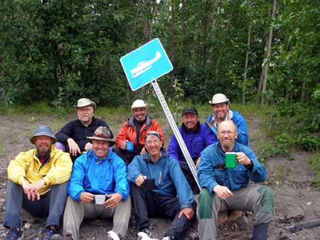
At Taco Bar, Black Sheep Aviation had put up a float-plane sign to indicate the take-out but it had been knocked over and only eagle-eyed Eric could spot it. (If you go, take note of the GPS co-ords and of the volcanic ash stripes in the cliffs on river right.)
The cliffs river right at Taco Bar. Note the layers of volcanic ash.
At Taco Bar, Black Sheep Aviation had put up a float-plane sign to indicate the take-out but it had been knocked over and only eagle-eyed Eric could spot it. (If you go, take note of the GPS co-ords and of the volcanic ash stripes in the cliffs on river right.)
Two sets of fresh bear prints greeted us at the take-out. As they were the same size and in the same direction, we assumed that this area was part of a regular route for the bear. We were there for about 12 hours, including overnight, but didn't catch a glimpse of it.
) Our ride home.
Our ride home.
) Hey those mountain walls are looking really close.
When heading back to Mayo we had to fly through several valleys where the mountains rose higher than the plane and their sides came relatively close to us. Then the weather started to close in and the visibility became — at least to me — very limited. Normally, I hate little airplanes — all airplanes, actually — but I had such great confidence in Grant, our pilot, that I rather enjoyed the whole trip. What a great change! Many thanks, Black Sheep.
Hey those mountain walls are looking really close.
When heading back to Mayo we had to fly through several valleys where the mountains rose higher than the plane and their sides came relatively close to us. Then the weather started to close in and the visibility became — at least to me — very limited. Normally, I hate little airplanes — all airplanes, actually — but I had such great confidence in Grant, our pilot, that I rather enjoyed the whole trip. What a great change! Many thanks, Black Sheep.
Tourist in Whitehorse
) SS Klondike National Park.
SS Klondike National Park.
) Sledding in comfort at the transportation museum.
We spent the day visiting various sites, such as the SS Klondike National Park. It is a fully and meticulously restored paddle-wheeler, one of three that used to ply the Yukon River between Whitehorse and Dawson. Many years ago, I spend a few weeks living on one of these paddle-wheelers while they were derelicts. Even back then I thought that one should be refurbished, so it was terrific to see such pride and attention given to its re-birth.
Sledding in comfort at the transportation museum.
We spent the day visiting various sites, such as the SS Klondike National Park. It is a fully and meticulously restored paddle-wheeler, one of three that used to ply the Yukon River between Whitehorse and Dawson. Many years ago, I spend a few weeks living on one of these paddle-wheelers while they were derelicts. Even back then I thought that one should be refurbished, so it was terrific to see such pride and attention given to its re-birth.
We also visited the Transportation Museum. Since it was the bush pilots and their planes that really opened up the Northcountry, the museum is predominately airplane-oriented. However, it still had many great artificats of the gold-rush era and the Alaska Highway.
Off to Skagway
) The Chilkoot Trail.
The Chilkoot Trail.
) The start of the Chilkoot Trail.
"At no other time or place in recorded history did so many people voluntarily subject themselves to so much agony and misery and death — and glory — than those twenty to thirty thousand who crossed the Chilkoot Pass on their way to the Klondike gold fields in 1897-98." - Archie Satterfield, Chilkoot Pass
The start of the Chilkoot Trail.
"At no other time or place in recorded history did so many people voluntarily subject themselves to so much agony and misery and death — and glory — than those twenty to thirty thousand who crossed the Chilkoot Pass on their way to the Klondike gold fields in 1897-98." - Archie Satterfield, Chilkoot Pass
Although it would be a far cry from the one ton of supplies that the N.W.M.P. made the seekers carry over the Pass, I think the Trail would be a fun challenge today. There are, apparently, lots of historical artifacts laying about and it would give an appreciation for just what these wayfarers had to do in their quest for gold. As it was, we just took a look then headed over to the Red Onion Saloon and Brothel for lunch and a beer.
Epilogue
What an fantastic trip: the Expediter was great; the floatplane flights were great; the scenery was great; the paddling was fun; even the touristing was good. Next time, it's the Wind's western sister: the Snake.
Some notable Co-ordinates
| Site | Co-ordinates | Notes |
|---|---|---|
| McClusky lake | N 64 34.0 W 134 25.7 | The Put-in |
| Confluence creek and Wind | N 64 34.46 W 134 28.6 | Campsite near old hunting cabin |
| Campsite #2 | N 64 36.58 W 134 33.2 | Good hiking river left, good campsite river right |
| Campsite #3 | N 64 47.4 W 134 39.5 | Fantastic campsite across from Bond Creek. Good hiking behind campsite. |
| Peel Canyon | N 65 56.912 W 134 51.398 | Just in case you get anxious |
| Taco Bar | N 66 0.187 W 134 13.0668 | The Take-out. Don't miss it! It's a long way to Fort McPherson |